


- On sale!
- -€65.76


 Secure payment gateway.
Apple Pay, Google Pay, credit card payment.
 Shipping to the EU for €5.99 or free on orders over €99.
Fast shipping via DHL (and partners). If in stock, 2–7 days across the EU.
 Need advice? Call us (English, Czech) or write to us (in your language).
+420 604 111 341 info@mojegs.cz
Created for Adventure
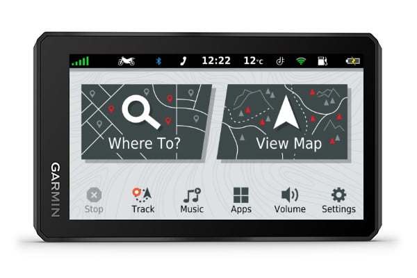 5.5" Large exceptionally bright display with HD resolution in multiple modes and excellent readability during the day and night. The dual orientation of the display allows you to choose whether to use the navigation in portrait or landscape mode. The screen can be operated even while wearing gloves and in any weather conditions. Thanks to the tempered waterproof glass (IPX7), you don't have to worry about the environment you are in. The navigation is highly resistant to shocks, water, dust, UV radiation, etc. Battery life at 100% screen brightness is up to 3.5 hours and in normal mode up to 6 hours. For longer trips, the navigation can be plugged into charging, so you won't be limited by battery life. The device can be paired with the inReach communicator. All these features make the Zumo® XT the ideal companion in any terrain.
Explore the Route
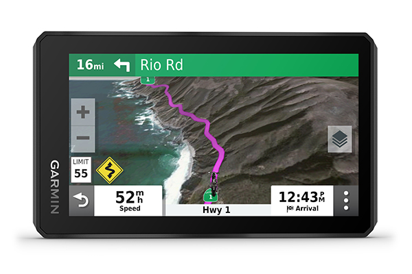 With a single click, switch between road map, detailed Topo map, and BirdsEye satellite imagery, ensuring you always have a detailed overview of the route. More demanding riders will appreciate outdoor topographic maps for off-road rides and terrain navigation. With BirdsEye satellite imagery, you can map the route in detail and adapt your riding style to the environment. The Garmin Adventurous Routing™ service offers exciting experiences on your favorite roads by calculating the route based on hilly terrain and the number of turns. The device also alerts you to sharp bends, changes in speed, and more. When connected to a mobile phone, you can view real-time data about traffic, accidents, and weather directly on the navigation. All rides can be recorded and shared with others. You can also use the popular TripAdvisor® platform to find hotels, restaurants, and attractions along your journey.
Data sheet

Garmin zumo XT PRO Europe45 is the new flagship of Garmin. A durable motorcycle navigation device with an exceptionally bright 5.5" HD display and free updates for maps of all of Europe and Topo Czech PRO available for download at no additional cost.


